Onder het thema "getij" vind je informatie over de getijgevoelige waterwegen en de Kust.
Het getij wordt vooral bepaald door de stand van de aarde, zon en de maan maar ook de windrichting en windsnelheid kunnen zorgen voor hogere of lagere waterstanden. We houden rekening met al deze fenomenen om tot een zo goed mogelijke inschatting van de waterhoogte te komen. De verwachting geven we per hoogwater en laagwater weer. Hoog- of laagwater komt altijd de Schelde binnen vanuit de Noordzee/Westerschelde en ontwikkelt zich dan verder landinwaarts.
Net zoals voor alle waterlopen worden er voorspellingen berekend aan de hand van computermodellen. Die bootsen de fysieke kenmerken van de getijgevoelige waterlopen en de aangrenzende zeeën na. We baseren ons voor de berekeningen niet alleen op neerslagvoorspellingen, maar ook op windvoorspellingen.
De permanentieverantwoordelijken van het HIC interpreteren deze modelresultaten voor het Scheldegebied en de verantwoordelijken bij het OMS voor de Belgische kust. Deze interpretatie vind je dagelijks terug in de waterinfoberichten voor Oostende, Zeebrugge, Antwerpen, Dendermonde en Melle.
Terug naar boven
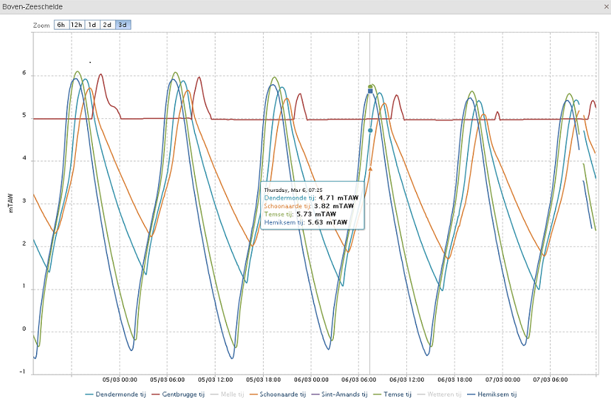
De actuele toestand toont de metingen in het tijgebied. In de actuele thema’s worden enkel metingen en geen resultaten van de voorspellingsmodellen getoond. Bovenop de metingen per meetstation, kan je de metingen van verschillende locaties in eenzelfde zone (bv. Beneden-Zeeschelde of Durme) opvragen in één overzichtelijke grafiek in de module tijgrafieken. Als je met de muis over de grafiek beweegt, kan je de waarden gemakkelijk aflezen. Door onderaan op de naam van de meetreeks te klikken, kan je een grafiek zichtbaar of onzichtbaar maken.

Voor het getijgebied van de Schelde rekenen er verschillende modellen bij het HIC. In de korte termijnvoorspellingen worden de modelresultaten van één model tot 48 uur vooruit weergegeven via de meetstations in de kaart. De vrijboordkaarten kleuren geel wanneer dat Scheldemodel voorspelt dat de waterstand bij hoogwater tot op minder dan één meter van de dijk zal komen. Ter hoogte van de GOG’s (Gecontroleerde overstromingsgebieden) is dat tijdens de springtijperiode regelmatig het geval.
De informatie van alle beschikbare modellen – waaronder ook Nederlandse modellen- en meteorologische bronnen wordt in normale omstandigheden twee keer per dag geïnterpreteerd. Hiermee worden dan de tijverwachtingen opgesteld.
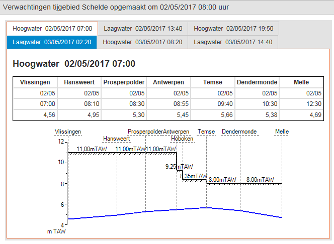
Langs de Schelde wordt een tijverwachting opgesteld voor de hoog- en laagwaters te Vlissingen (RWS) , Hansweert (RWS), Prosperpolder, Antwerpen, Temse, Dendermonde en Melle. De waardes in de tijverwachtingen zijn dus steeds meer betrouwbaar dan de modeloutput in de grafieken op de kaart. De tijverwachtingen worden immers steeds manueel opgesteld en gecontroleerd. Je vindt de tijverwachtingen via de Verwachtingen in het tijgebied van de Schelde’.

Voor de Kust worden gelijkaardige stappen gedaan door het OMS in opdracht van MDK.
Een set van locaties met de belangrijkste tijverwachtingen in Vlaanderen wordt opgenomen in de waterinfoberichten.
De verwachtingen voor Antwerpen of Oostende kunnen leiden tot de afkondiging van Stormtij in het Zeescheldebekken of Stormtij Kust. Deze fases worden ingesteld door de respectievelijke beheerders, nl. W&Z nv en MDK. In deze fase worden de tijverwachtingen frequenter opgesteld en worden er door de waterbeheerder ook gepaste maatregelen genomen zoals het installeren van dijkbewaking, het sluiten van de poorten in de keringsmuur te Antwerpen, preventieve maatregelen,...
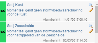
Wanneer (Gevaarlijk) Stormtij Kust of (Gevaarlijk) Stormtij Schelde van kracht is, wordt dit aangegeven in de alarmberichten op de getijpagina’s.

Terug naar boven
Op de downloadpagina zijn nu ook de astronomische voorspellingen voor het tijgebied beschikbaar.
Deze voorspellingen worden door het HIC van het Waterbouwkundig Laboratorium 1 keer per jaar opgemaakt voor het volgende jaar. We streven ernaar dit eind april klaar te hebben.
Astronomische voorspellingen schatten het getijverloop met hoog-en laagwater aan de hand van de astronomische wetmatigheden en metingen uit het verleden die de morfologische invloed van het Schelde-estuarium in zich dragen. Ze geven een zo goed mogelijk beeld bij gemiddelde weerscondities. De Korte-termiijn voorspellingen en getijverwachtingen, die slechts enkele dagen op voorhand gemaakt kunnen worden, houden wel rekening met de weersvoorspellingen en zijn dus betrouwbaarder op de korte termijn.
Traditioneel worden de astronomische voorspellingen voor de hoofdlocaties Prosperpolder, Antwerpen en Wintam gepubliceerd. Om tegemoet te komen aan de stijgende vraag naar astronomische voorspellingen elders en verder opwaarts in het tijgebied, worden vanaf heden ook voorspellingen voor andere locaties ter beschikking gesteld via de downloadfunctie. De gebruiker dient zich er van bewust te zijn dat de gebruikte methodologie voor het opstellen van de astronomische voorspellingen minder accuraat wordt als de invloed van bovenafvoer naar het Schelde-estuarium groter wordt. Met andere woorden: hoe verder opwaarts in het Scheldegebied, hoe groter de onzekerheid op de astronomische voorspellingen.
U vindt de downloadpagina via de knoppen Metingen/Downloaden of via www.waterinfo.be/downloaden.
Er zijn tijdsreeksen beschikbaar met enkel de hoog-en laagwaters in via Astronomische voorspellingen getij (HWLW). Via de keuze voor Astronomische voorspellingen (Continu- 10 minuut) kunnen continuë reeksen gedownload worden.
Voor verdere vragen over deze astronomische voorspellingen kan u terecht bij hic@vlaanderen.be.
Terug naar boven